Some symbols seem pretty straightforward on a nautical chart. Yet there’s a reason for them to be there.

Question of the week
🔹 What does this arrow symbol mean on nautical charts?
And bonus questions
🔹 Where is it most often found?
🔹 And most of all, why is it added on charts?
👉 Reply on one of our social media below. We’ll post the solution right here next Sunday!
Arrow clarifying the direction of buoyage
The short answer is that these symbols represent the direction of buoyage where it is not obvious. To understand where this could happen and why, here’s a bit of background.
The lateral buoyage system is widely known. Simply made up of two marks, it is commonly used, whether heading into a harbor, going upriver, or more generally when proceeding from offshore to inshore. In these instances, no clarification is usually required as to the direction in which the channel should be followed.
On a side note, the one obvious caveat is to take into account which IALA region the navigator is in. Zone B encompasses the Americas, as well as South Korea, Japan, Taiwan and the Philippines. Zone A encompasses Europe (including Greenland), Africa, Australasia and Asia with the exceptions listed above. But mariners are generally pretty aware which zone they’re in, so there’s no ambiguity there.

(Map @ Wikimedia Commons)
Why and where is buoyage direction not obvious?
So, then, how could the buoyage direction not be obvious? This happens when there are clear navigational channels, but where these are not clearly oriented from seaward in. If there is no clear “channel”, then cardinal markers are more appropriate. But if there is a channel going along the coast, the generally agreed upon convention is to go clockwise around landmasses, which makes it simple around an island for example.
But what happens when multiple islands intertwine and create multiple channels? It would then become very difficult to determine the correct buoyage direction with certainty. Hence, when spotting a lateral mark, it would not be clear if it is to be kept to port or starboardRight side of a boat when looking forward More. This is why the direction of buoyage arrow can (and should) be added to a nautical chart.
This arrow exists in a standard, single-color version. Since multicolored charts become more common, the arrow can also be found with a red and green color dot (these being on the left or right depending on the IALA region).
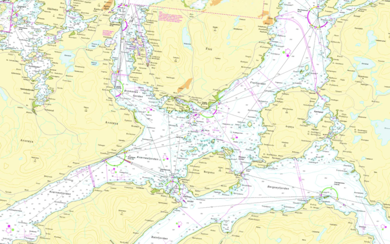
As stated above, the symbol is most often found in complex archipelagoes, or in multiple sounds. One example coming to mind is in the fjords of Norway. No less than eight of them can be found in the following frame, taken from a chart just south of Kristiansund. Can you spot them all? If you can think of other examples of these arrows, please post them on our social media!

@ Kartverket
Our next quiz on autopilots is now live and awaiting your answer!
